

Castle Rock is a prominent rock outcropping rising above the north shore of Blue Mountain Lake. This popular hike provides spectacular views of the lake.
| Directions | From Long Lake, proceed south on Rte. 30 towards Blue Mountain Lake. As you approach Blue Mountain Lake you'll pass the entrance for the Adirondack Experience (formerly the Adirondack Museum), continue for .4 miles and take a right on Maple Lodge Road. Follow this road for 1.2 miles to parking on the left. Access is through the grounds of the Minnowbrook Conference Center so be respectful of the private property. |
| Difficulty | Easy-Moderate. The round trip covers 2.8 miles with an elevation gain of 550 feet. The climbing is mostly gradual with two short steep sections just before the top. |
| Family-Friendly | Yes. Smaller children will need help to safely navigate a short steep stretch just before the top. But, overall, this trail is easy the whole way. |
| Winter | This is a popular snowshoeing route but a several steep stretches make it a poor route for skiers. One particularly steep pitch near the top tends to be covered with hard ice and micro-spikes are needed to safely navigate this section in winter. |
| One Thing to Know | As you approach the top of the mountain the trail passes below cliffs with caves and huge boulders to explore. The summit provides a 180 degree view oriented towards the south east. Blue Mountain Lake and Eagle Lake appear close at hand. Bullhead Mountain and Snowy Mountain are two of the prominent peaks on the skyline to the southeast. |
| DEC Website Page | Blue Mountain Wild Forest |
| Photo Gallery | Castle Rock Photo Gallery |
From the parking area, follow the gravel road past the trail register. The trail follows this road for two tenths to an intersection with signs directing you to the right. Continuing for another tenth of a mile you come to a second intersection. Turn left, and cross the bridge, this is the most direct route to Castle Rock. The trail straight ahead goes to Upper Sargent Pond. It also connects with a continuation of the Castle Rock trail near the summit, making a loop hike possible. The loop route adds a half mile to the total distance.

On the direct route, the trail reaches an intersection after three fourths of a mile. The Castle Rock Trail bears to the right and the route to the left drops down to a landing on Blue Mountain Lake allowing for an approach by boat. Watch for this intersection. There is a sign but it is easy to miss.
Continuing, the trail climbs steadily at a moderate grade for a half mile before flattening out just below the top. The trail passes cliffs and huge boulders with caves and rock formations to explore. At 1.3 miles (from the parking) you reach the intersection with the trail that continues past the summit to connect with the Upper Sargent Pond Trail, turn right. The trail ascends steeply for the last one-tenth mile and care is needed in this section. Just before the top you pass through a narrow cleft in the summit rocks. Just past that point, the open rocks of the summit appear on the right. You are now on top of the cliffs passes a few minutes earlier with spectacular views of Blue Mountain Lake and the mountains beyond.
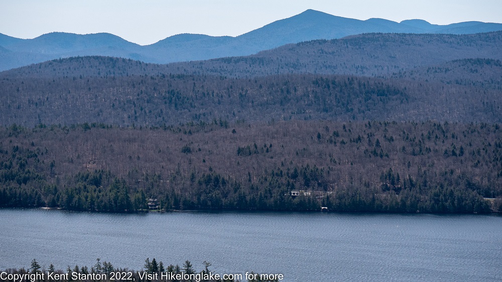
Blue Mountain Lake from Castle Rock
Connected Trails: From the intersection just below the top, the Castle Rock Loop Trail proceeds for .4 miles to join the trail to Upper Sargent Pond. That trail can be followed back to the parking area.
The Upper Sargent Pond Trail proceeds for 4.5 miles to the east end of the pond. The trail passes near Helms Pond, and much of the route is along a stream much beloved by the beaver who have dammed it at numerous points. This little used trail provides an alternative the more popular approach to Upper Sargent from the North Point Road near Long Lake.